
Please click on the map to open larger in a separate window or click the Garmin link to zoom in, see elevation gains/losses, pace and distance information (not available for first two legs)
For all transit schedules and stop locations, please go to 511.org to get the most up to date and accurate information for your own journeys.
*On some transit lines, such as Golden Gate, you must scan your Clipper Card when you off-board as well as when you on-board.
There were some sections of the Bay Trail such as Highway 37 or the Lincoln Highway along San Pablo Road that are still in the planning stages and were either not accessible or safe for pedestrian access at the time of my trip. In these cases I received assistance to get to the next trail head.
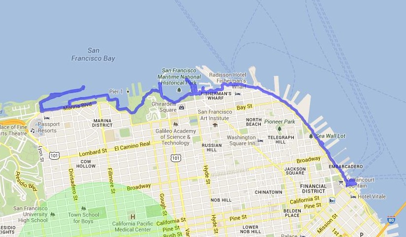
May 31st: “warm-up” from the Ferry Building to St. Francis Yacht Club
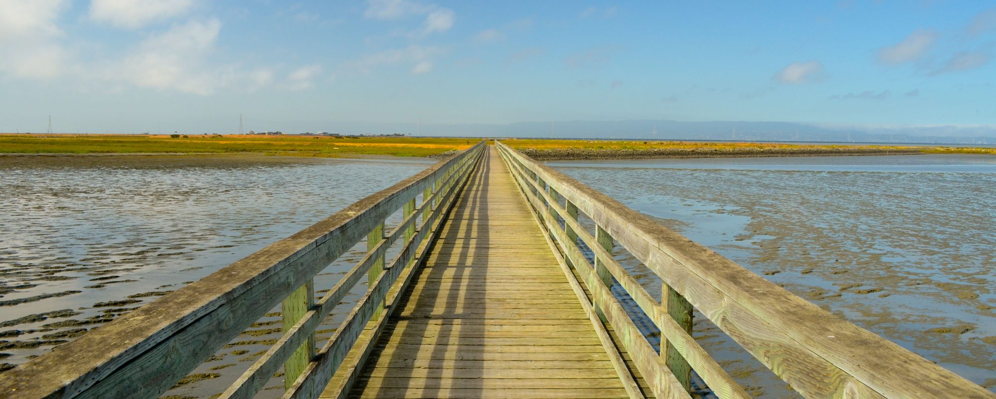
Distance: About 5 miles (8km) if you throw in the “wave organ” east of the St. Francis Yacht Club and the Hyde Street Pier
Transportation to start: SF Muni 1 California to Drumm, walked one block to The Bay Trail.
Transportation home: Walked back to Fillmore and took the 22 back up the hill to Pacific Heights

June 1: St. Francis Yacht Club to Sausalito
Distance: 6.7 miles (10.8km) to the Sausalito Ferry Terminal (This map shows an additional 2 miles to the Marin City bus depot)
Transportation to start: SF Muni 22 Fillmore to the Marina
Transportation home: Golden Gate Transit bus back to Fillmore and Lombard in San Francisco

June 2nd, Sausalito to Tiburon
For full hike stats go to http://connect.garmin.com/course/3780989
Distance: 13.4 miles (21.6km) (Starting at Marin City Bus depot)
Transportation to start: Golden Gate Transit direct to Marin City from Lombard and Fillmore (.25 mile walk to Bay Trail)
Transportation home: Blue and Gold Ferry service from Tiburon to pier 41 in San Francisco – $11 – (NOTE: No Clipper card service on Blue and Gold Fleet), Walked one block to SF Muni 47 to Pacific and Van Ness

June 3rd, Tiburon to Larkspur
For full hike stats go to http://connect.garmin.com/course/3792541
Distance: 11.66 miles (18.76km)
Transportation to start: Golden Gate Transit from SF (Lombard and Fillmore) to Tiburon (w/transfer in Marin City)
Off-board downtown Tiburon onto The Bay Trail
Transportation home: Golden Gate Ferry Service from Larkspur to San Francisco Ferry Building. Transfer to 1 California line.

June 4th, Larkspur to San Rafael
NOTE: I highly recommend turning left after the first mile onto Anderson Drive then right onto Bellam to get to the San Rafael Bay shoreline, rather than taking the freeway on-ramp shoulder as I did and is shown on this map. The shoulder is not safe and cars travel at very high rates of speed here. Also, from Pickleweed Park I did not follow the existing Bay Trail but rather tested a proposed trail. From Pickleweed Park, I recommend heading south on Kerner for about a half mile then right onto Bellam, go under the freeway and turn right onto the Bay Trail which follows Anderson.
For full hike stats go to http://connect.garmin.com/course/3800449
Distance: 6.36 miles (10.23km)
Transportation to start: SF Muni 1 California to Ferry Building, Golden Gate Ferry service to Larkspur
Off-board downtown Larkspur onto The Bay Trail
Transportation home: Golden Gate Transit 101 Express (10 past the hour) to Lombard and Fillmore

June 5th, San Rafael Transit Center to McInnis Park (San Rafael)
For full hike stats go to http://connect.garmin.com/course/3809902
Distance: 15 miles (24.14 km)
Transportation to start: Golden Gate Transit at Fillmore and Lombard (5:45am), off-board at San Rafael Transit Center
Transportation home: Marin Transit from McInnis Park (Yosemite and Smith Ranch Road) to San Rafael Transit Center ($2, no Clipper on Marin Transit) then transfer to the Golden Gate Transit 101 Express. Ride to Lombard and Fillmore was less than 20 minutes!
PLEASE NOTE: June 6th is my one and only designated drive day. There is no pedestrian access to Highway 37 and Public transportation does not service the Sonoma shoreline, therefore I drove to these sections as well as to the two northern most legs, McInnis Park and Hamilton Wetlands Restoration, which I folded into this day.
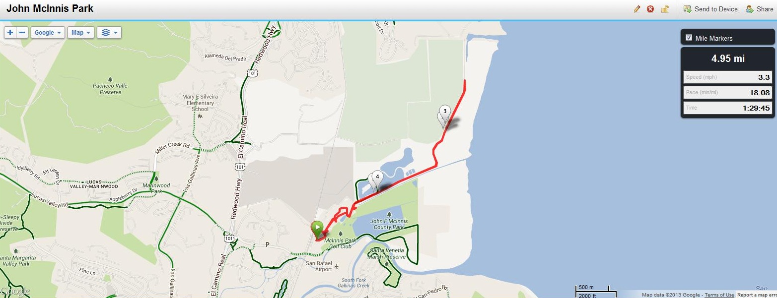
June 6th, John McInnis Park, San Rafael
For full hike stats go to http://connect.garmin.com/course/3818802
Distance: 4.95 miles (7.97km)

June 6th, Hamilton Wetlands Restoration, Novato
For full hike stats go to http://connect.garmin.com/course/3818867
Distance: 2.48 miles (4km)
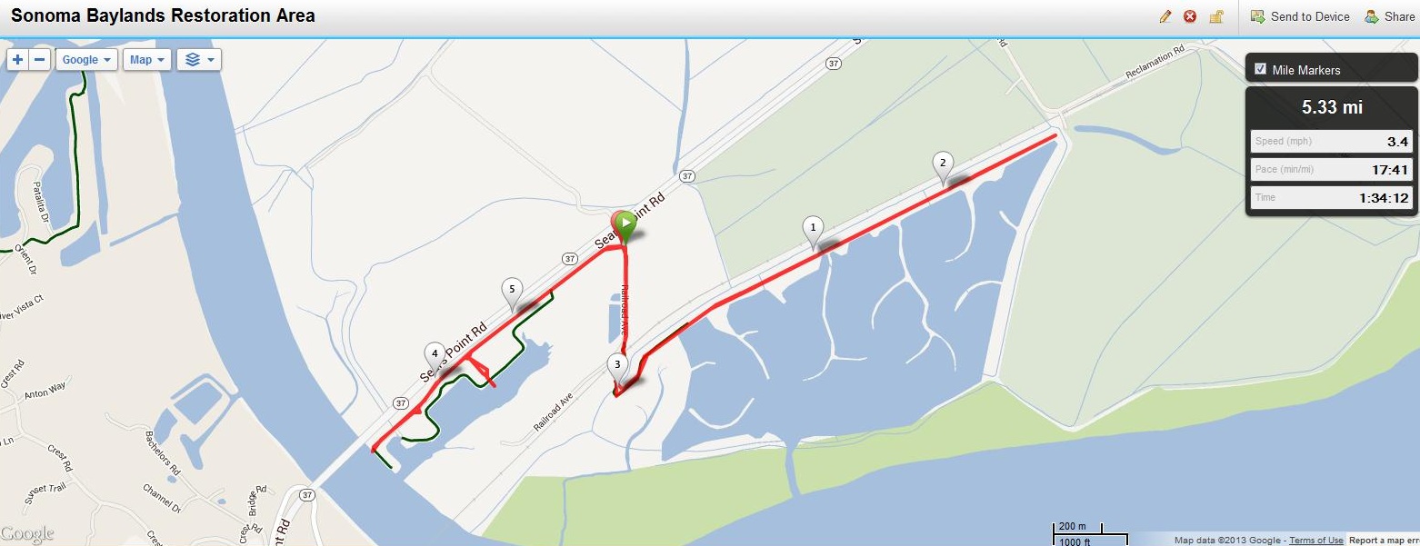
June 6th, Sonoma Baylands Restoration Area
For full hike stats go to http://connect.garmin.com/course/3818896
Distance: 5.33 miles (8.58km)
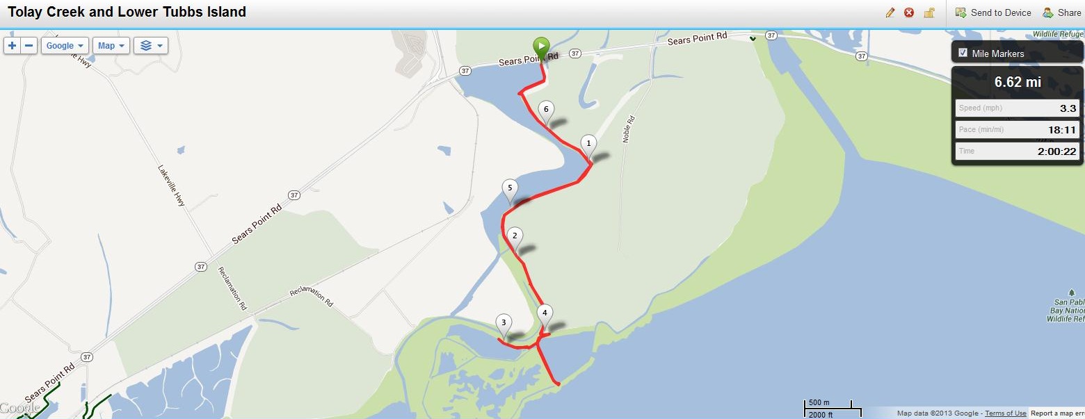
June 6th, Tolay Creek and Lower Tubbs Island
For full hike stats go to http://connect.garmin.com/course/3819195
Distance: 6.62 miles (10.65km)
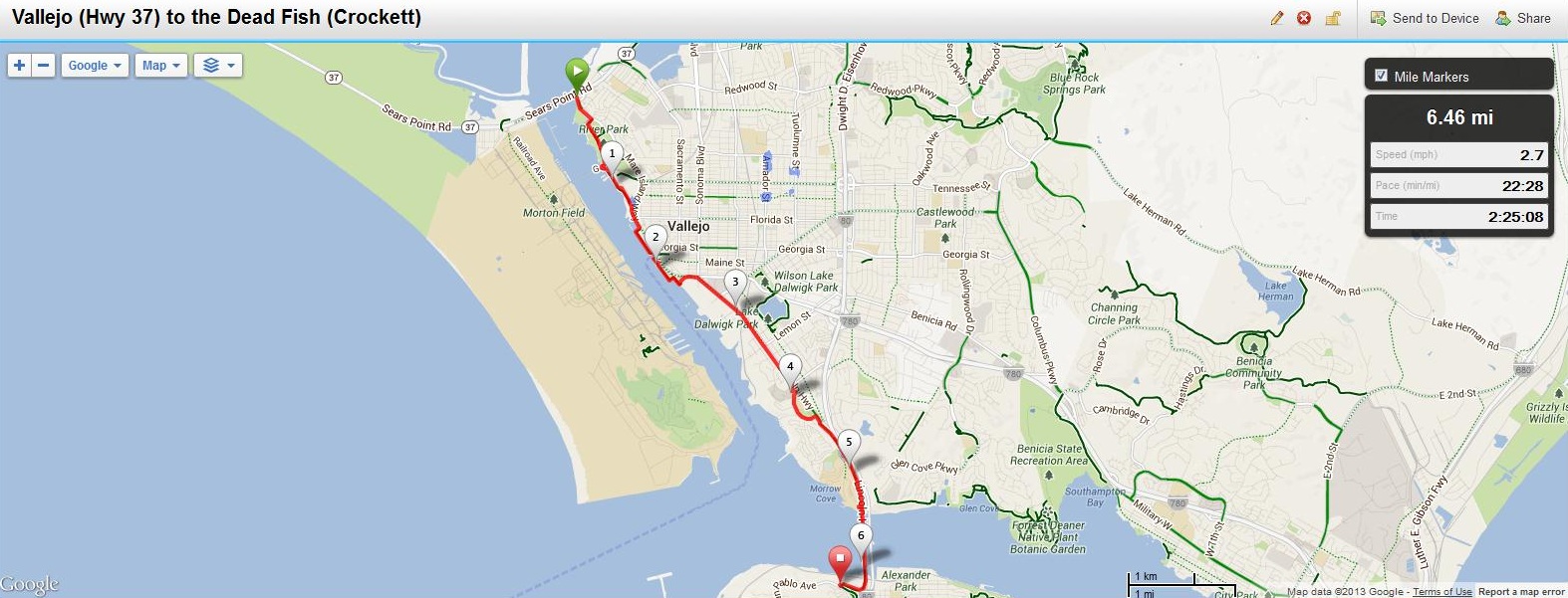
June 7th: Vallejo (Hwy 37) to Crocket (The Dead Fish Restaurant)
For full hike stats go to http://connect.garmin.com/course/3828442
Distance: 6.46 miles (10.4km)
Transportation to start: San Francisco Ferry to Vallejo
Transportation home: The Lincoln Highway (San Pablo Blvd.) section of the Bay Trail just south of the Carquinez Bridge is still in the planning stages. There is no safe pedestrian passage along this road. I received assistance at this point and was dropped off at BART for my trip home. For bus service, WestCat offers connecting service to BART in Western Contra Costa County. Please go to 511.org for information on stop locations and times.
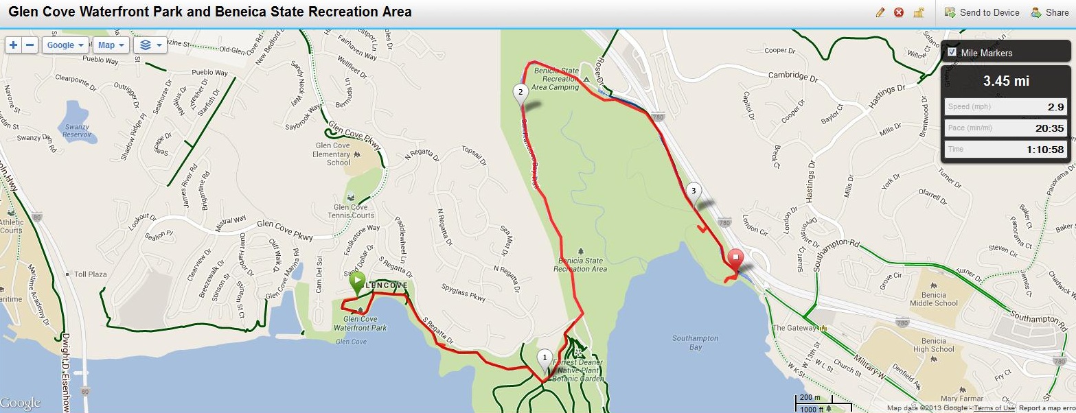
June 7th: Glen Cove Waterfront Park and Benecia State Recreation Area
For full hike stats go to http://connect.garmin.com/course/3828662
Distance: 3.45 miles (5.55km)
Since the Bay Trail section connecting Vallejo to Glen Cove and Benecia is still in the planning stages these areas are inaccessible from Vallejo on foot. I received assistance to get to Glen Cove.
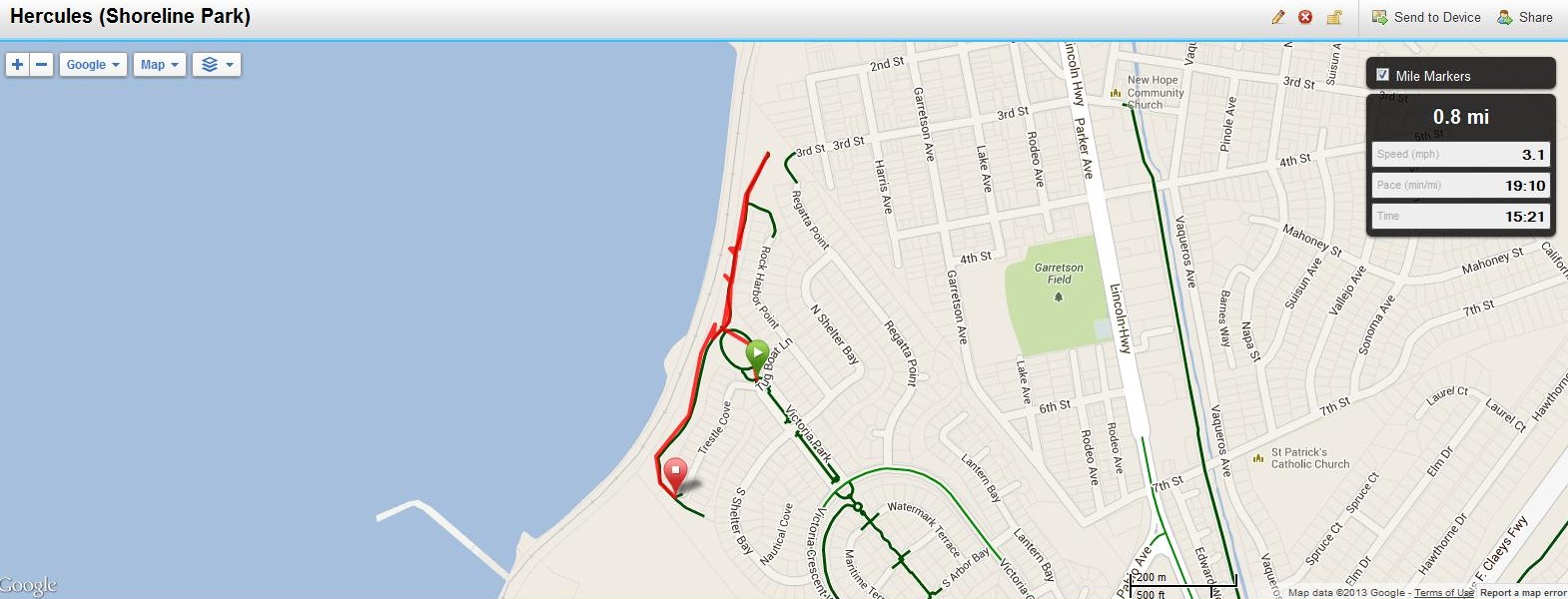
June 7th: Hercules (Shoreline Park)
For full hike stats go to http://connect.garmin.com/course/3828739
Distance: .8 miles (1.29km)
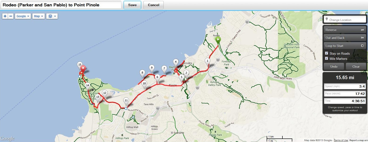
June 8th, Rodeo to Point Pinole
For full hike stats go to http://connect.garmin.com/course/3852498
Distance: 15.63 miles (6km)
Transportation to start: Embarcadero BART (SF) to El Cerrito Del Norte BART, transfer to WestCat JR (No Clipper – $1)
Transportation home: AC 71 from Richmond Detention Center (adjacent to Point Pinole on Giant Highway) to Richmond BART, Offboard at Embarcadero BART in SF
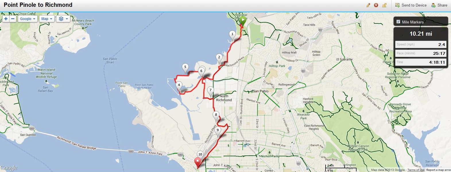
June 8th, Point Pinole to Point Richmond
For full hike stats go to http://connect.garmin.com/course/3852448
Distance: 10.21 miles (16.43km)
Transportation to start: Embarcadero BART (SF) to Richmond BART
Transportation home: Richmond BART to Embarcadero BART (SF)
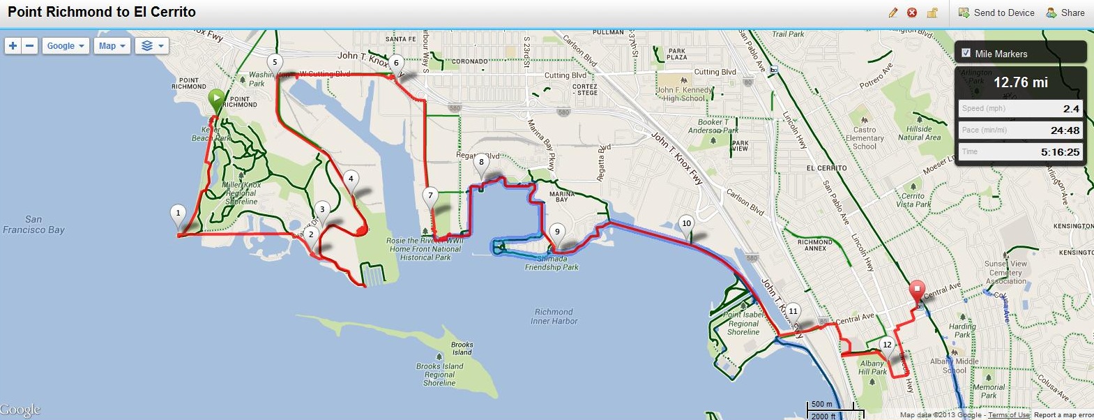
Point Richmond to Pt. Isabel & El Cerrito
For full hike stats go to http://connect.garmin.com/course/3862430
Distance: 12.76 miles (20.53km)
Transportation to start: Embarcadero BART (SF) to Richmond BART
Transportation home: El Cerrito BART to Embarcadero BART (SF)
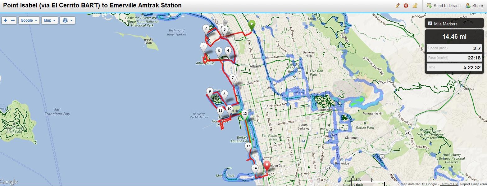
June 11: Pt. Isabel (Started at El Cerrito BART) to Emeryille (Amtrak Station)
For full hike stats go to http://connect.garmin.com/course/3871447
Distance: 14.46 miles (23.27km) from El Cerrito BART and includes Pt. Isabel loop
Transportation to start: Embarcadero BART (SF) to El Cerrito Plaza BART
Transportation home: EmeryGoRound on Hollis across from Amtrak (free) to McArthur BART (Oakland) to Embarcadero BART (SF)
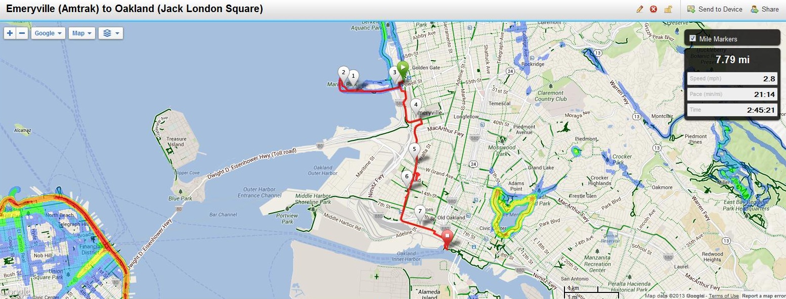
June 12: Emeryille (Amtrak Station) to Oakland (Jack London Square)
For full hike stats go to http://connect.garmin.com/course/3879746
Distance: 7.79 miles (12.54km)
Transportation to start: Embarcadero BART (SF) to McArthur BART (Oakland) to EmeryGoRound
Transportation home: Oakland Ferry (Jack London Square) to San Francisco (Ferry Building)

June 13: Alameda (Main Street Ferry) to Oakland (High Street Bridge)
For full hike stats go to http://connect.garmin.com/course/3886294
Distance: 7.19 miles (11.57km)
Transportation to start: San Francisco Ferry Service from SF Ferry Building to Alameda (Main Street)
Transportation home: Oakland (Fruitvale BART) to San Francisco (Embarcadero BART)
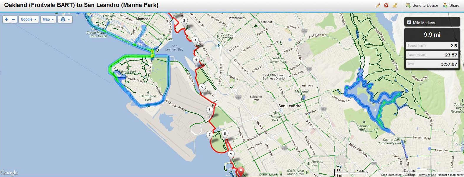
June 14: Oakland (Fruitvale BART) to San Leandro (Marina Park)
For full hike stats go to http://connect.garmin.com/course/3894575
Distance: 9.9 miles (15.93km)
Transportation to start: San Francisco (Embarcadero BART) to Oakland (Fruitvale BART)
Transportation home: AC Transit 81 – Monarch Bay Dr/Mulford Pt to San Leandro BART to San Francisco (Embarcadero BART)
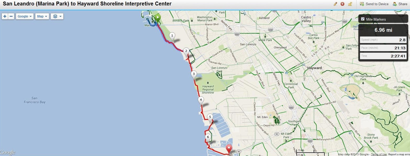
June 15: San Leandro (Marina Park) to Hayward Shoreline Interpretive Center
For full hike stats go to http://connect.garmin.com/course/3905887
Distance: 6.96 miles (11.20km)
Transportation to start: San Francisco (Embarcadero BART) to San Leandro BART
Transportation home: AC Transit 86 from Cabot and Depot Roads (No weekend Service) to South Hayward BART to San Francisco (Embarcadero BART)
On weekends I recommend bringing your bike on BART and riding to the shoreline where there are miles of unpaved trails that are bike friendly.

June 16: Hayward Shoreline Interpretive Center to Fremont (Ardenwood Historic Farm/Highway 84)
For full hike stats go to http://connect.garmin.com/course/3918925
Distance: 9.67 miles (15.62km)
Transportation to start: San Francisco (Embarcadero BART) to Hayward BART (No weekend bus service to HSIC) On weekends I recommend bringing your bike on BART and riding to the shoreline where there are miles of unpaved trails that are bike friendly, otherwise it is a $30 cab ride.
Transportation home: AC Transit 345 at Newark and Jarvis Blvd to Union City BART to San Francisco (Embarcadero BART) – Transfer at Bayfaire
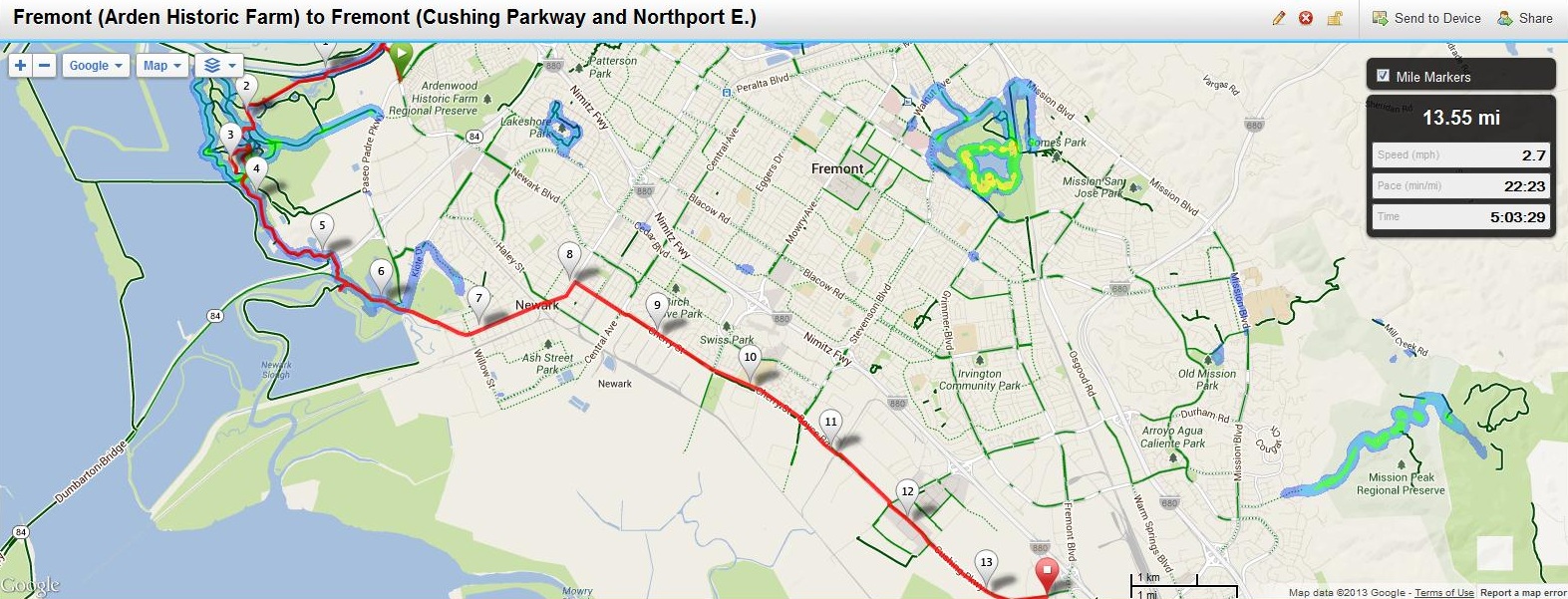
June 17: Fremont (Ardenwood Blvd. and Paseo Padre) to Fremont (Cushing Parkway and Nortport Loop East)
For full hike stats go to http://connect.garmin.com/course/3928486
Distance: 13.55 miles (21.81km)
Transportation to start: San Francisco (Embarcadero BART) to Union City BART to AC Transit 232 (Offboard at Ardenwood and Paseo Padre and walk north to Alameda Creek trailhead)
Transportation home: AC Transit 212 at Cushing Parkway and Northport Loop East to Fremont BART to San Francisco (Embarcadero BART)
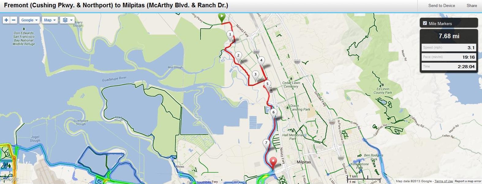
June 18: Fremont (Cushing Parkway and Nortport Loop East) to Milpitas (North McArthy Blvd. and Ranch Dr.)
For full hike stats go to http://connect.garmin.com/course/3938058
Distance: 7.67 miles (12.34km)
Transportation to start: San Francisco (Embarcadero BART) to Fremont BART to AC Transit 212, Offboard at Cushing Parkway and Northport Loop East
Transportation home: VTA 47 from North McArthy Blvd and Ranch Dr. to Great Mall, Transfer to VTA 180 (Fremont BART Express) Fremont BART to SF Embarcadero BART
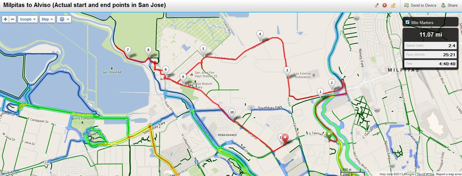
June 19: Milpitas (Started at E. Tasman & Cisco in San Jose) to Alviso (Ended at E. Tasman & Baypoint in San Jose)
For full hike stats go to http://connect.garmin.com/course/3946102
Distance: 11.07 miles (17.81km)
Transportation to start: San Francisco (Embarcadero BART) to Fremont BART to AC Transit 212, Offboard at E. Tasman and Cisco in San Jose, Walk about 300 yards east to Coyote Creek trail head then north for 1.7 miles north along Coyote Creek Trail until you reach the Bay Trail trail head at N. McArthy and Ranch Dr.
Transportation home: VTA Lightrail from E. Tasman and Baypoint (San Jose) to Great Mall, Transfer to VTA Fremont BART Express. Fremont BART to SF Embarcadero BART (NOTE: There are VTA stops in Alviso however there is not regular service. I walked about 2 miles to E. Tasman and Baypoint in San Jose since Alviso service was not available mid-day)
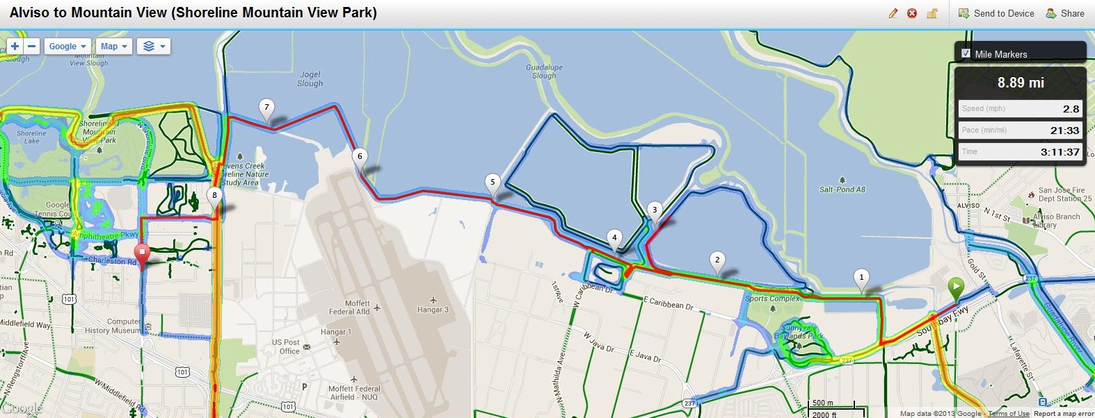
June 20: Alviso to Mountain View (Shoreline)
For full hike stats go to http://connect.garmin.com/course/3954427
Distance: 8.89 miles (14.31km)
Transportation to start: San Francisco (Embarcadero BART) to Fremont BART to VTA 140, Offboard at Tasman and Zanker in San Jose, Walk to SE corner of Tasman and Zanker and catch the VTA 58 to Alviso (Bus stop is about 50 yards south of Tasman on Zanker – check 511.org for times)
Transportation home: Southbound VTA 40 on Shoreline at Charleston to Southbound 35 at Showers and California to CalTrain
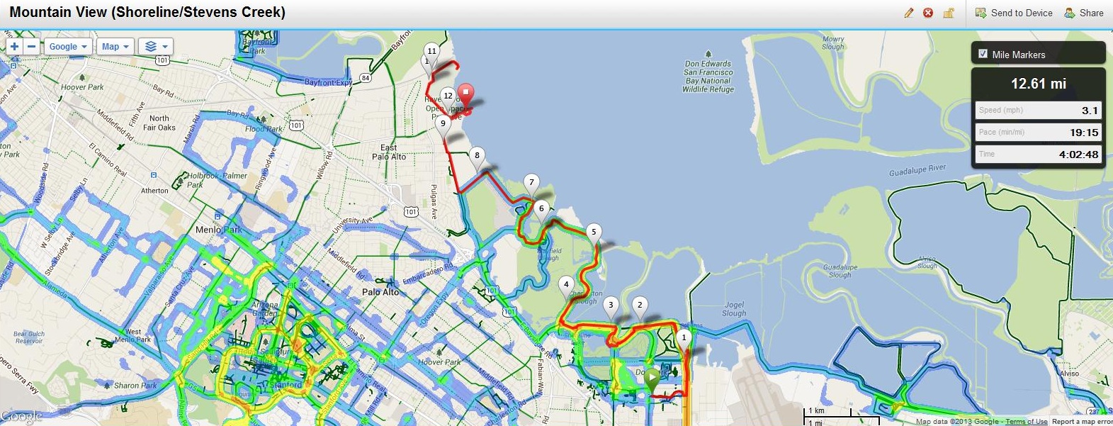
June 21: Mountain View (N. Shoreline or Stevens Creek to Bay Trail) to East Palo Alto (Cooley Landing)
For full hike stats go to http://connect.garmin.com/course/3961692
Distance: 12.61 miles (20.29km)
Transportation to start:
Option 1) San Francisco CalTrain to Mountain View Station, walk 2 Miles East on N. Shoreline to Charleston and turn in at Steven Creek Trailhead, head east to Bay Trail
Option 2) San Francisco CalTrain to San Antonio Station, walk to California and Showers and board the VTA 40 to Shoreline and Charleston then to Steven Creek Trailhead
Transportation home: From Cooley Landing, walk 1 mile west to catch the SamTrans 296 from University and Bay in East Palo Alto to Menlo Park CalTrain
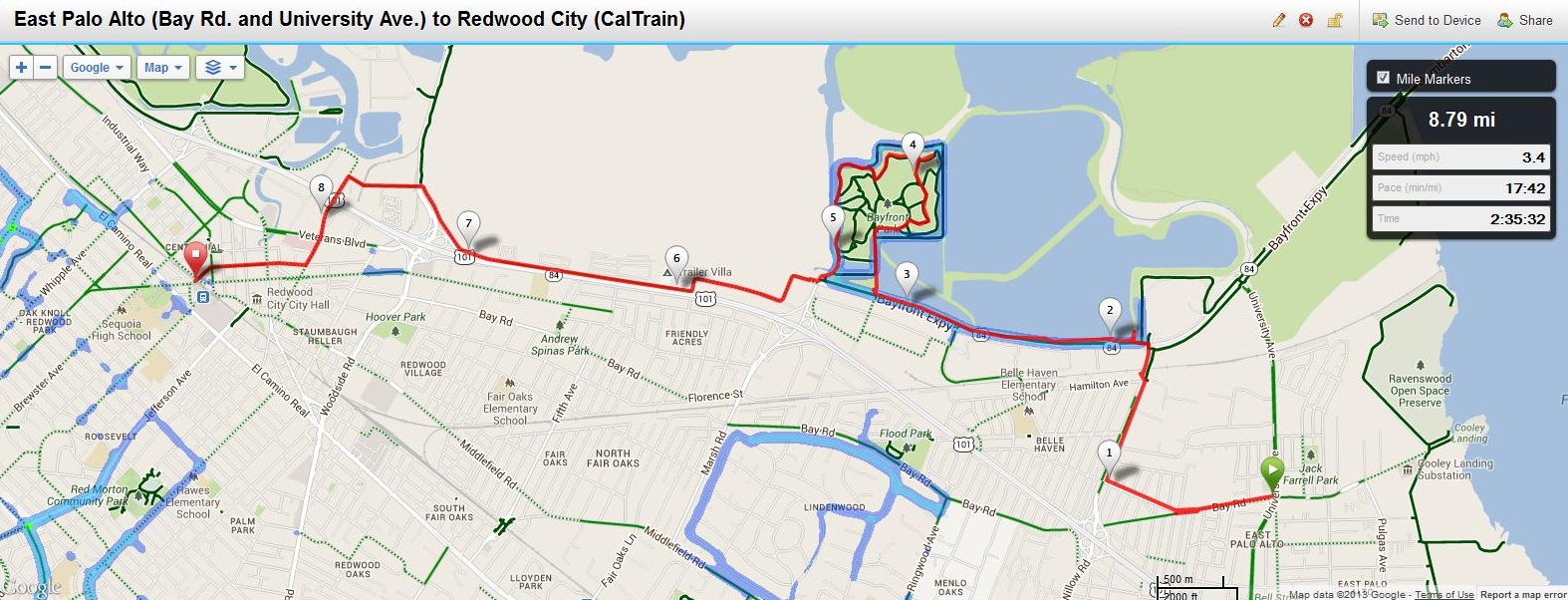
June 22: Ravenswood (East Palo Alto: Bay Rd. and University Ave.) to Redwood City (CalTrain)
For full hike stats go to http://connect.garmin.com/course/3971226
Distance: 8.79 miles (14.15km)
Transportation to start: San Francisco CalTrain to Palo Alto Station, Transfer to SamTrans 281, Offboard at Bay Rd. and University. Walk east on University to Highway 84 for most direct route to BayTrail. (NOTE: I took a slightly different route, see map)
Transportation home: Redwood City CalTrain to San Francisco CalTrain. (Appoximately 1 mile to BayTrail) Alternatively, SamTrans 270 bus from Bayfront Park to Redwood City CalTrain.
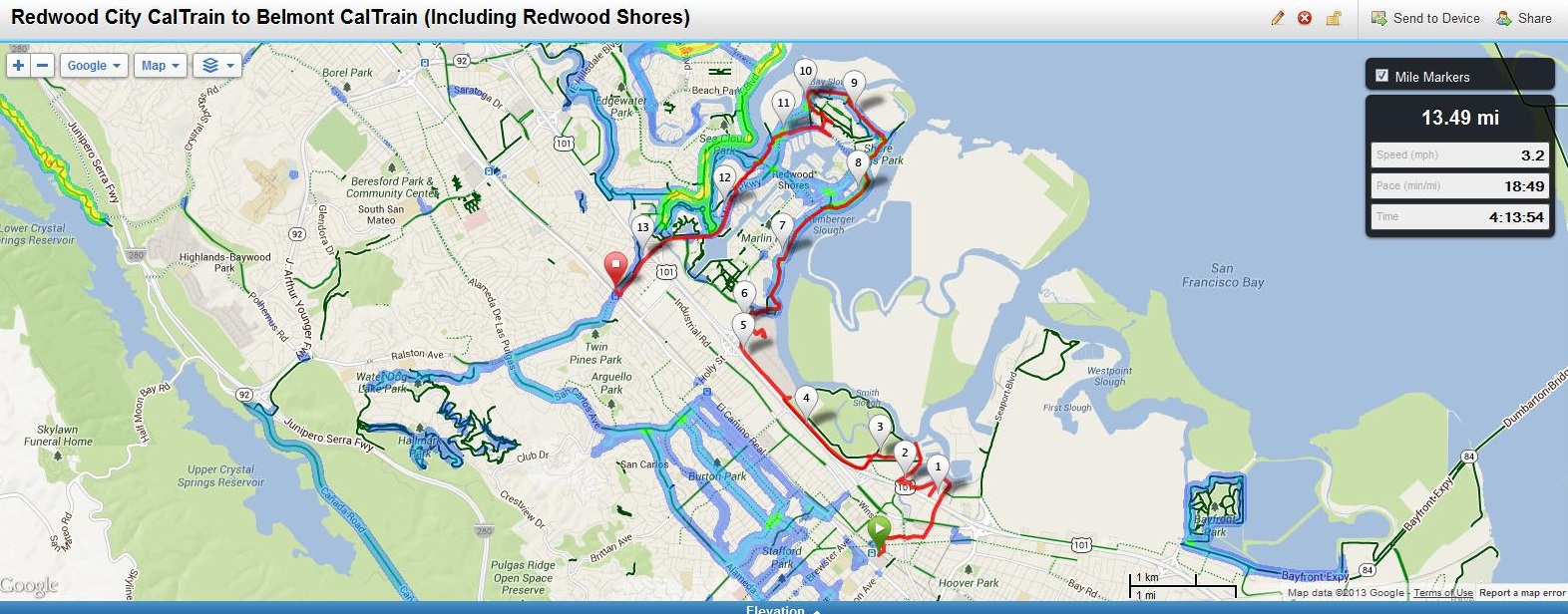
June 23: Redwood City CalTrain to Belmont CalTrain (including Redwood Shores)
For full hike stats go to http://connect.garmin.com/course/3984172
Distance: 13.49 miles (21.71km)
Transportation to start: San Francisco CalTrain to Redwood City CalTrain (Appoximately 1 mile to Bay Trail)
Transportation home: Belmont CalTrain to San Francisco CalTrain (Appoximately 1 mile to Belmont CalTrain)
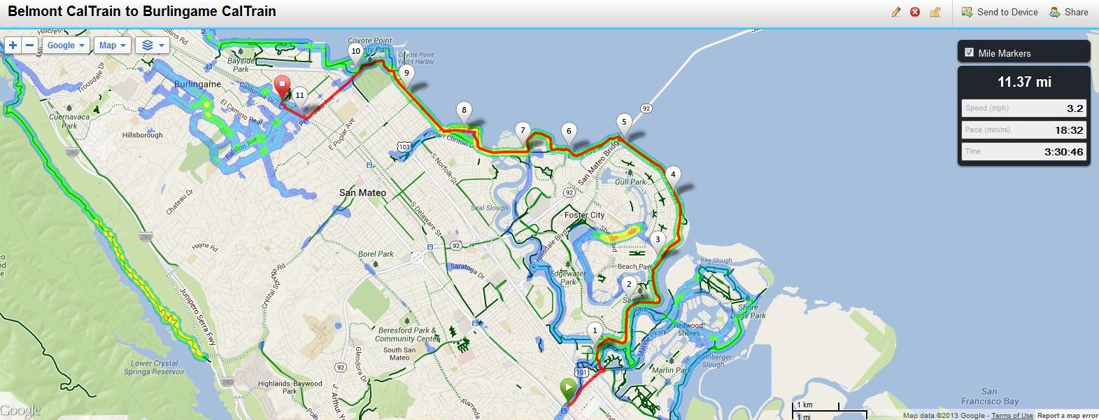
June 24: Belmont CalTrain to Burlingame CalTrain
For full hike stats go to http://connect.garmin.com/course/3993208
Distance: 11.37 miles (18.30km)
Transportation to start: San Francisco CalTrain to Belmont CalTrain (Appoximately 1 mile walk to Bay Trail)
Transportation home: Burlingame CalTrain to San Francisco CalTrain (Appoximately 1.3 mile walk to Burlingame CalTrain from Bay Trail)
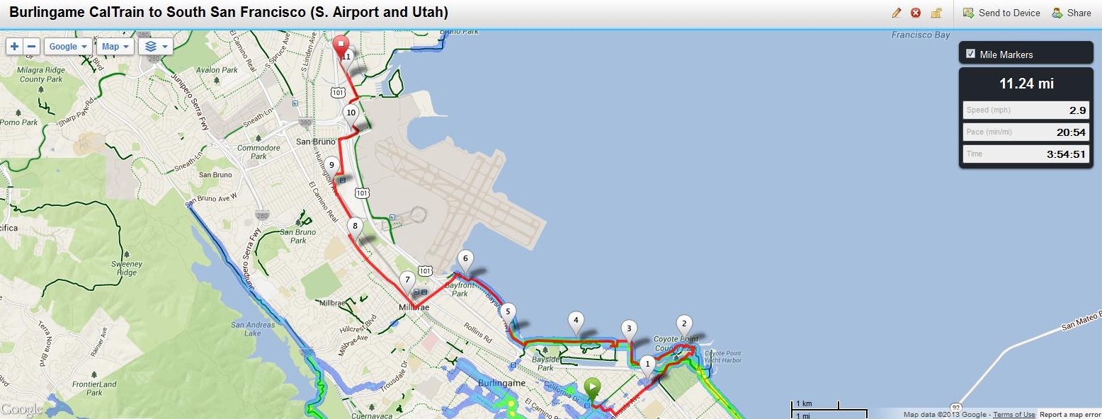
June 25: Burlingame CalTrain to South San Francisco (S. Airport Blvd. and Utah Ave.)
For full hike stats go to http://connect.garmin.com/course/4002141
Distance: 11.24 miles (18.09km)
Transportation to start: San Francisco CalTrain to Burlingame CalTrain (Appoximately 1.3 mile walk to Bay Trail)
Transportation home: South San Francisco (SamTrans bus 292 from S. Airport Blvd. and Utah Ave.) to San Francisco (3rd and Mission)
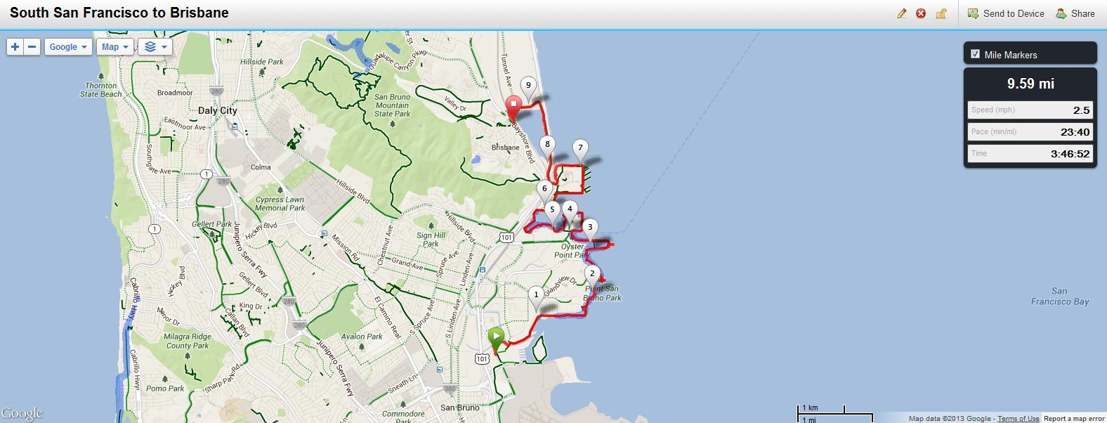
June 26: South San Francisco (S. Airport Blvd. and Utah Ave.) to Brisbane (Tunnel Road and Bayshore Blvd.)
For full hike stats go to http://connect.garmin.com/course/4009533
Distance: 9.59 miles (15.43km)
Transportation to start: San Francisco (SamTrans 292 from Mission and 5th) to South San Francisco (Belle Aire Rd. and South Airport Blvd.)
Transportation home: Brisbane (SamTrans 292 from Old Tunnel Road and Bayshore Blvd.) to San Francisco (3rd and Mission)
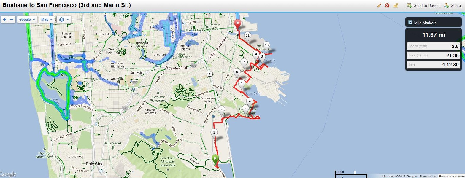
June 27: Brisbane (Tunnel Road and Bayshore Blvd.) to San Francisco (3rd and Marin Street)
For full hike stats go to http://connect.garmin.com/course/4017656
Distance: 11.67 miles (18.78km)
Transportation to start: San Francisco (SamTrans 292 from Mission and 5th) to South San Francisco (Belle Aire Rd. and South Airport Blvd.)
Transportation home: Brisbane (SamTrans 292 from Old Tunnel Road and Bayshore Blvd.) to San Francisco (3rd and Mission)
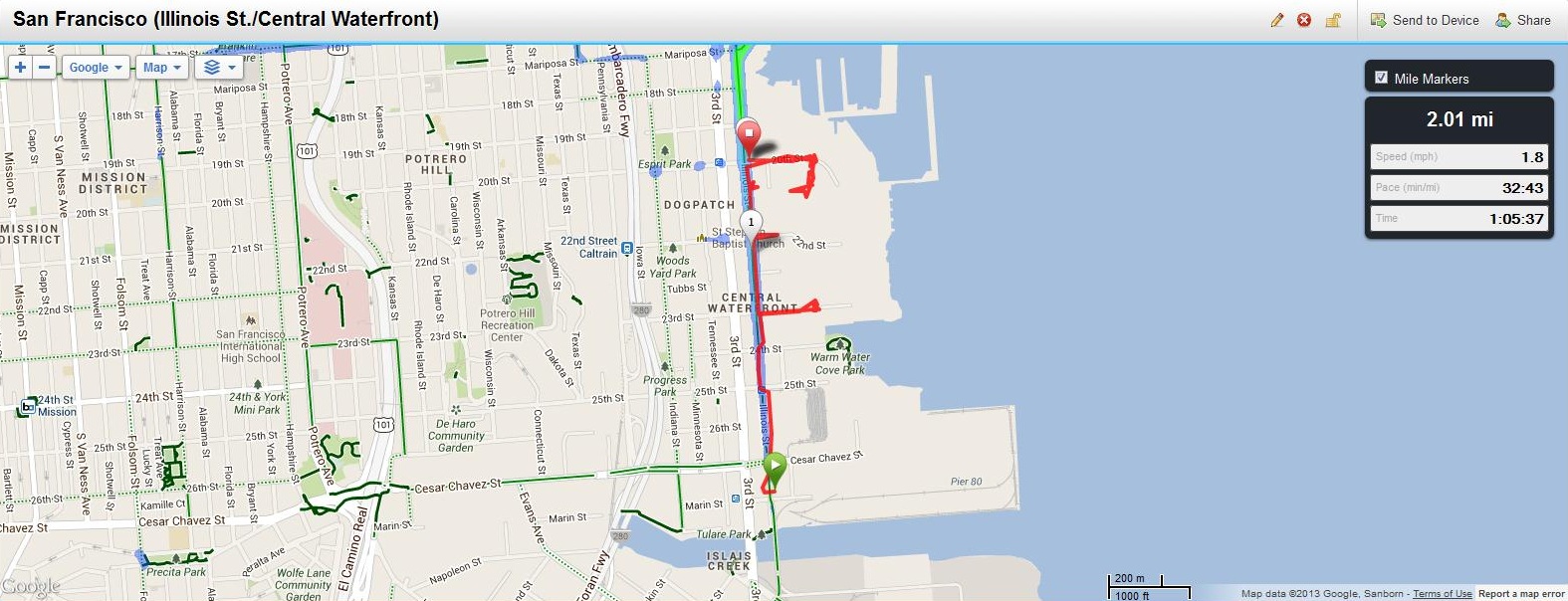
June 28: San Francisco (Central Waterfront)
For full hike stats go to http://connect.garmin.com/course/4024797
Distance: 2.01 miles (3.23km)
Transportation to start: San Francisco (MUNI T 3rd Street Lightrail)
Transportation home: San Francisco (MUNI T 3rd Street Lightrail)
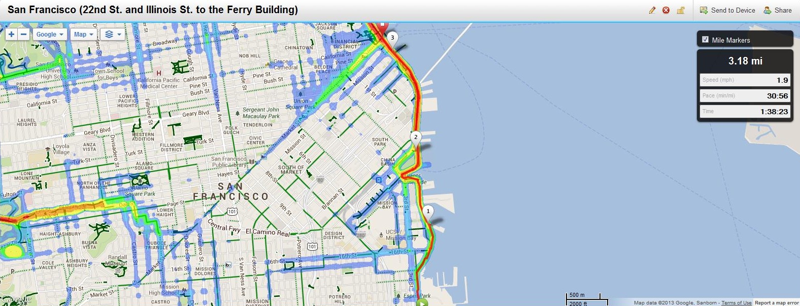
June 29: San Francisco (22nd and Illinois to the Ferry Building)
For full hike stats go to http: http://connect.garmin.com/course/4035343
Distance: 3.18 miles (5.12km)
Transportation to start: San Francisco (MUNI T 3rd Street Lightrail from Embarcadero to 20th Street)
Transportation home: San Francisco: None – I AM HOME:)


